|
|
|
|
|
|
|
|
|
|
|
|
|
|
Habitats Palustrine System. Forested Mineral Soil Wetlands Subsystem-- Floodplain forest community
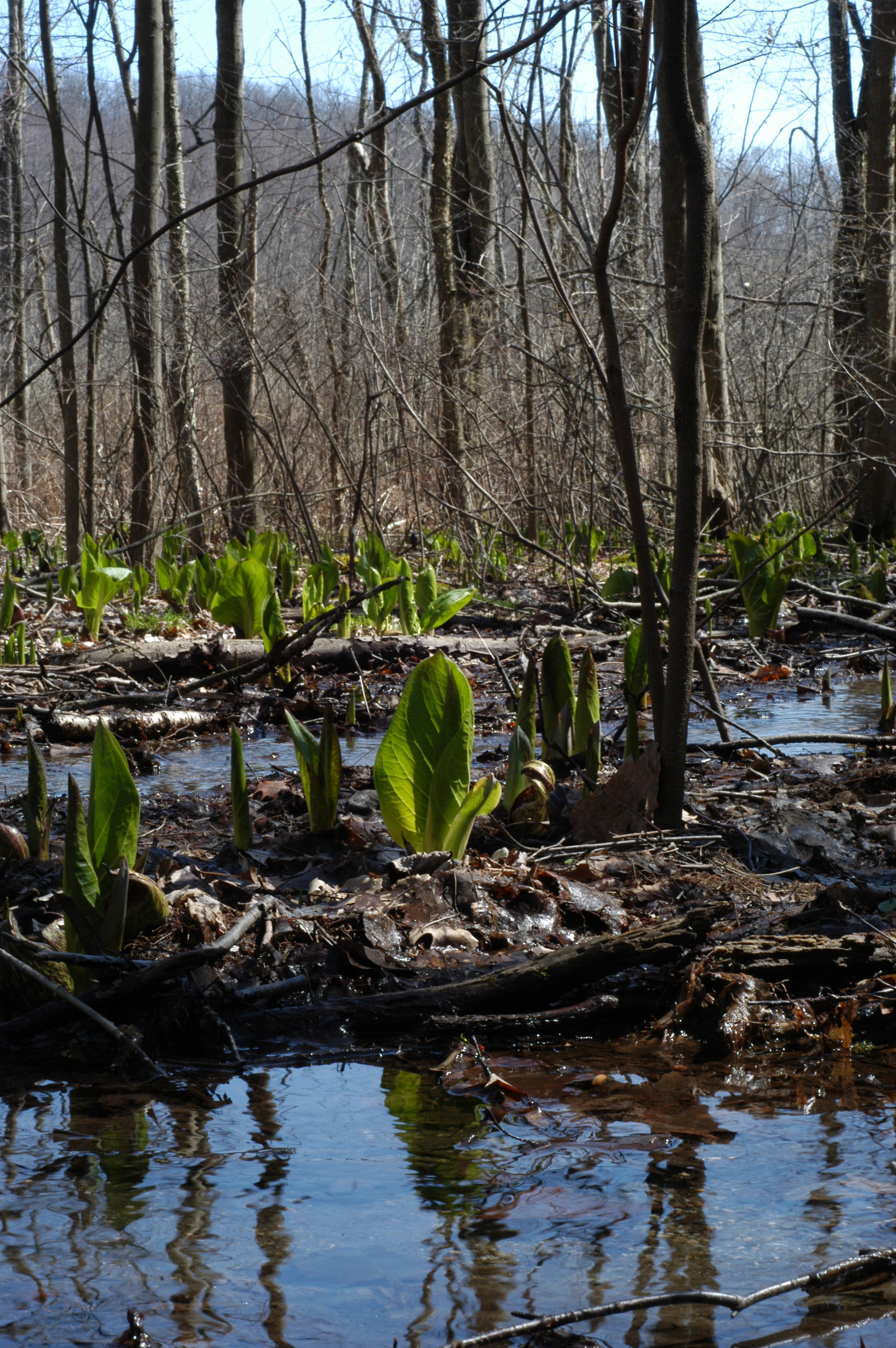
Physical Setting: These communities occur along three stream courses-- two west and one east of the Ice Pond. The two largest systems (both western) are watered from the same spring system originating in Hemlock-northern hardwood forest in a hill west of Ice Pond Road at approximately 41.451ºN, 73.622ºW (± 50 m) and 225 meters above sea level. The first stream course (554 m long) runs directly east through Appalachian oak-hickory forest and then down a steep slope through (or under) the Ice cave talus community surrounded by Rich mesophytic forest. It then broadens in the flat lowlands west of a Red maple-hardwood swamp west of the Ice Pond. The second stream course (1.76 km long) flows together with the first for about 100 meters, but diverges to the north, then passes westward through a pipe under Ice Pond Road, where it joins another un-named stream before passing through a pipe back to the east side of Ice Pond Road and into a broad, gently sloping valley surrounded by Appalachian oak-hickory forest. The stream course then runs by and through a Sedge meadow and eventually turns eastward and into a Red maple-hardwood swamp west of the Ice Pond. The third stream course (557 m long) is watered from springs below Hemlock-northern hardwood forest at approximately 41.446ºN, 73.614ºW (± 25 m) and 145 meters above sea level. It flows directly north between hills covered by Hemlock-northern hardwood forest to the east and the east branch of the Metro North Railroad tracks to west. Substrate and Hydrology: These forests are underlain by rich mineral soil that is flooded to a depth of about 10 centimeters throughout the year. In exceptionally dry periods the ground remains saturated, but there may be little standing water. Biota: The vegetation is dominated by tall trees with a closed canopy between eighteen and twenty-five meters from the ground, but individual species vary with slope and substrate. Dominant trees in all three Floodplain forests may include Ulmus americana L, Acer rubrum L, Populus deltoides Marshall, Populus grandidentata Michx, Populus tremuloides Michx. and Nyssa sylvatica Marshall. The only Acer saccharinum L. occurs in the Floodplain forest near the fishing lodge. It is not evident whether this tree is spontaneous or was planted. Throughout the community, Lindera benzoin (L.) Blume dominates the shrub layer. Vaccinium corymbosum L. occurs in isolated patches, particularly on the upper portion of the first stream course. The herb layer is dominated by Symplocarpus foetidus (L.) Nutt., Caltha palustris L., Viola cucullata Aiton, Onoclea sensibilis L., Osmunda cinnamomea L, Osmunda regalis L., Osmunda claytonia L., Carex bromoides Willd subsp. bromoides and Cinna arundinacea L. The third floodplain forest is very narrow throughout its course and the diversity of woody and herbaceous vegetation is lower than in the other two. Cultural: The first and second Floodplain forests are traversed by numerous stone walls and in the second which mostly passes through Appalachian oak-hickory forest, the larger trees appear to be even-aged, suggesting that the area was clear-cut and probably drained until sometime in the early 20th Century. The eastern-most portion of the first Floodplain forest occurs over and around the remains of the old icehouse and must have been completely clear-cut and drained. |
Copyright © The New York Botanical Garden