Monte Pascoal National
Park
 Monte
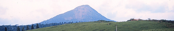
Pascoal, a peak 586 m high, was the first land sighted when the Portuguese
discovered Brazil in 1500. The Park was dedicated in 1961 at which
time it covered 22,500 ha; the Park's area was later reduced to 14,000
ha, with most of the excluded territory given to the local Pataxós
Indian tribe (Padua & Coimbra Filho 1989, Soares & Ascoly 1970).
Some of the 14,000 ha, especially the part nearest the coast, have been
exploited by the Pataxós and are disturbed. The park lies
ca. 250 km south of Ilhéus and extends westward from the coast 30
km to Monte Pascoal (16º53'-16º58'S, 39º07'-39º25'W;
see satellite image). The area receives approximately 1,500-1750
mm per year of rainfall with 1-2 dry months per year. Annual temperatures
average 22-24ºC (IBAMA/BA without date). The vegetation of the
eastern part of the Park is restinga
and mangrove and of the western part, southern Bahian wet forest over laterite.
Monte
Pascoal, a peak 586 m high, was the first land sighted when the Portuguese
discovered Brazil in 1500. The Park was dedicated in 1961 at which
time it covered 22,500 ha; the Park's area was later reduced to 14,000
ha, with most of the excluded territory given to the local Pataxós
Indian tribe (Padua & Coimbra Filho 1989, Soares & Ascoly 1970).
Some of the 14,000 ha, especially the part nearest the coast, have been
exploited by the Pataxós and are disturbed. The park lies
ca. 250 km south of Ilhéus and extends westward from the coast 30
km to Monte Pascoal (16º53'-16º58'S, 39º07'-39º25'W;
see satellite image). The area receives approximately 1,500-1750
mm per year of rainfall with 1-2 dry months per year. Annual temperatures
average 22-24ºC (IBAMA/BA without date). The vegetation of the
eastern part of the Park is restinga
and mangrove and of the western part, southern Bahian wet forest over laterite.
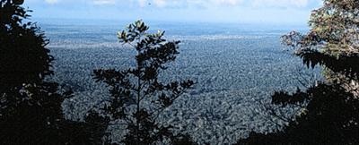
View east across the Park from the top of Monte Pascoal
Contact Us | ©2005 Wm. Wayt Thomas, The New York Botanical Garden