From the Field: Bill Buck in Cape Horn 2013, Day 16
Posted in Bill Buck, From the Field, Science on March 12 2013, by William R. Buck
January 25, 2013, Prov. Antártica Chilena, Comuna Cabo de Hornos, Isla Navarino, Seno Grandi, 55°14’S, 67°46’W
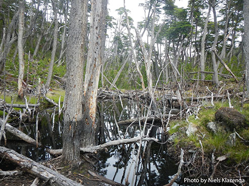 The ship begins moving in the early morning hours and the potentially rough seas never really materialize. I think for most of us it is instead like being rocked in a cradle. When we stop we are halfway up the north side of Seno Grandi. Our collecting site is along a large river that empties into a lake. About half of us go up the east side of the river, and the rest to the west. Although not cold or raining, a steady strong wind makes the Zodiac trip ashore wet and rough. As we approach the shore we can see quite clearly that the landscape is heavily disturbed. There are remnants of abandoned dwellings and piles of crab traps. It appears that beaver have caused significant damage to the landscape as well, and that the large peatland to the west of the river is courtesy of an ancient beaver dam.
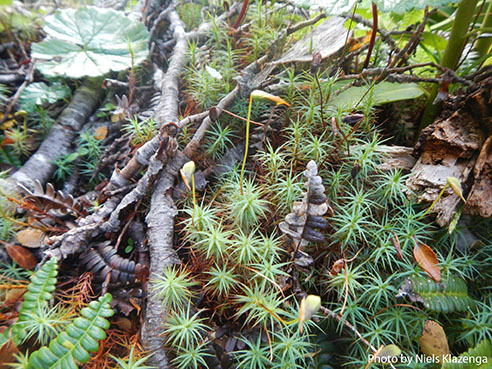 Of course the bryophytes don’t know the origin of their habitat though, and grow with abandon on these diverse surfaces. The forest byroflora proves pretty depaupreate, but where a beaver has felled a large southern beech I find a very nice moss–Ulota–in the canopy as well as two different lichens that were using the moss as a substrate. The peatland, with all three of our local Sphagnum species, is very reminiscent of our boreal peatlands, but with a considerably smaller number of species of Sphagnum. Apparently some of the hepatics are the same as those found in northern peatlands.
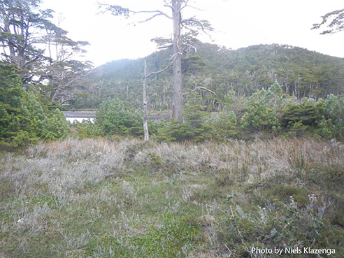 Because we want to hit a second site in the afternoon we only stay out until noon. As we eat lunch, the captain moves the ship to its current position at the eastern end of the sound. Here the landscape is more windswept and–with the exception of sheltered habitats in the distance–the only woody plant is the local barberry, Berberis ilicifolia, and its existence is only as a smattering of scattered shrubs. Nevertheless, the barberry twigs host a few epiphytic mosses which prove obtainable only by payment of multiple puncture wounds from the spiny leaves and nasty thorns on the shrubby plants. Otherwise the only bryophytes we find are those eking out a bleak existence in small patches at the bases of the vascular plants.
The drama of the afternoon involves a mink. Laura is the first to spot the juvenile mink running along the shore. Shortly after, Ernesto, in the Zodiac, spots it and comes ashore, and then chases it with the shovel he uses to take soil samples. The mink dives back into the sea, the Zodiac hot on its tail. The mink decides to return to shore where it is stoned to death by Juan. I am well aware that the mink here–all of which are based on populations escaped from fur farms–are an invasive species and are doing tremendous damage to the local fauna. Just a few days ago researchers with the Omora group were telling us about how many of the Magellanic woodpeckers they have banded end up in mink burrows. However, it is hard for me to imagine how one less mink will make much of a difference. I cannot watch the act and deep down feel it is cowardly.
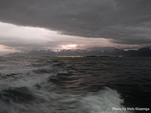 The captain has decided the wind will make the seas on the south coast of Navarino too rough for us to cross to Isla Lennox, and so we will take the longer, northerly route. This means an early departure and that we must be back on the ship by 5 p.m. He has advised us to take to our bunks between 6 and 8 p.m., during which time we will be in the Antarctic wind-roughened waters. Dinner will be served after as we travel all night to reach the islands east of Navarino. I hope the seas won’t be quite as bad as predicted, but regardless I am happy that we are taking the longer, but calmer route. The captain says that if we were to do the shorter, southern route that the seas are likely to be so rough that we would be thrown out of our bunks!
Ed. note: NYBG scientist and Mary Flagler Cary Curator of Botany, Bill Buck has just returned from his annual expedition to the islands off Cape Horn, the southernmost point in South America, to study mosses and lichens. For the past two years he was able to file stories from the field, but this year’s locations proved so remote he was forced to wait until his return. We will be publishing them over the course of several days. Follow his journeys on Plant Talk.
Bill Buck’s Previous Reports From the Field:
2013
January 10, 2013, Punta Arenas, Chile
2012
February 5, 2012; Isla Londonderry, Puerto Fortuna, approximately 54º54’S, 70º26’W
February 4, 2012; Isla O’Brien, Caleta Americana, approximately 54º53’S, 70º23’W
February 3, 2012; Isla Grande de Tierra del Fuego, Fiordo Garibaldi, approximately 54º58’S, 69º49’W
February 2, 2012; Isla Gordon, middle arm of Bahía Tres Brazos, approximately 54º58’S, 69º41’W
January 31, 2012; Isla Gordon, Bahía Romanche, 54º57’S, 69º30’W
January 30, 2012; Isla Gordon, Bahía Romanche, 54º57’S, 69º30’W
January 25, 2012; Isla Darwin, Caleta Virginia, approximately 54º57’S, 70º10’W
January 23, 2012; Arm of Estero Webb, SW coast of Isla Hoste, approximately 55º14’S, 69º41’W
January 22, 2012.; Unnamed sound on Isla Gordon behind Cabo El Gorro, approximately 55º02’S, 69º48’W
January 21, 2012; Isla Hoste, Estero Fouque, 55º1’S, 69º35’W
January 20, 2012; Isla Hoste, Estero Fouque, approximately 55º11’S, 69º35’W
January 18, 2012; Canal O’Brien, just south of Isla O’Brien, 54º55’S, 70º35’W
January 17, 2012; Punta Arenas, Chile
2011
July 15, 2011; Hobart, Tasmania, Australia
July 14, 2011; Pyengana, Tasmania, Australia
July 13, 2011; Weldborough, Tasmania, Australia
July 12, 2011; Hobart, Tasmania, Australia
July 11, 2011; Hobart, Tasmania, Australia
February 8, 2011; Punta Arenas, Chile
February 5, 2011, unnamed sound northwest of Isla Georgiana
February 4, 2011, unnamed sound directly east of Seno Mama, Chile
February 2, 2011, Seno Courtenay, northern arm, Chile
February 1, 2011, Seno Courtenay, Chile
January 31, 2011, Canal between Isla Georgiana and Isla Clementina,, Chile
January 30, 2011, Unnamed sound on south side of Brecknock Peninsula, NW of Isla Georgiana, Chile
January 29, 2011, Isla Aguirre, Seno Quo Vadis, Chile
January 26, 2011, Punta Arenas, Chile
January 24, 2011, Seno Chasco, just north of isthmus to Brecknock Peninsula, Chile
January 23, 2011, Isla Grande de la Tierra del Fuego, Puerto Consuelo, Seno Chasco, Chile
January 22, 2011, Isla Grande de la Tierra del Fuego, Seno Brujo, Chile
January 21, 2011, Isla Grande de la Tierra del Fuego, Seno Brujo, Chile
January 20, 2011, Isla Grande de la Tierra del Fuego, Seno Bluff, Chile
